


Geography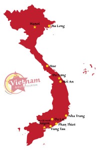
Vietnam occupies the eastern and southern part of the Indochinese peninsula in Southeast Asia, with the South China Sea along its entire coast. China is to the north and Laos and Cambodia are to the west. Long and narrow on a north-south axis, Vietnam is about twice the size of Arizona. The Mekong River delta lies in the south.
From the capital Hanoi in the north down to Ho Chi Minh City in the south it will take approximately 2 hours and 30 minutes to fly or 1,710kms driving 29 hours along the country’s coast line.
Golf Regions by Distance
Vietnam
Hanoi to Da Nang
| by Air | approx. 1hour 15 minutes |
| by Road | approx. 15 hour (917 kms.) |
Ho Chi Minh City to Da Nang
| by Air | approx. 1hour 15 minutes |
| by Road | approx. 15 hour 47 minute (854 kms.) |
Ho Chi Minh City to Dalat
| by Air | approx. 50 minutes |
| by Road | approx. 6 hour (279 kms.) |
Ho Chi Minh City to Ho Tram
| by Road | approx. 75 minutes (110 kms.) |
Ho Chi Minh City to Phan Thiet
| by Road | approx. 4 hours 20 minutes (212 kms.) |
Asia
Siem Reap, Cambodia to Ho Chi Minh City
| by Air | approx. 1hour |
Bangkok, Thailand to Ho Chi Minh City
| by Air | approx. 1hour 30 minutes |
Phuket, Thailand to Hanoi
| by Air | approx. 4 hour 30 minutes |
Current Information
President: Truong Tan Sang (since 2011)
Prime Minister: Nguyen Tan Dung (2006)
Population (2014 est.): 93,421,835 (growth rate: 1%)
- Birth Rate: 16.26/1000
- Infant Mortality Rate: 18.99/1000
- Life Expectancy: 72.91
- Density per Sq.mi.: 703
Land area: 125,622 sq mi (325,361 sq km) total area: 127,244 sq mi (329,560 sq km)
Capital: Hanoi, 7.1 million (metro. area), 2.955 million (city proper)
Largest cities:
- Ho Chi Minh City (Saigon), 8,190,775
- Haiphong 925,000
- Da Nang 834,000
Monetary unit: Dong
Languages:
- Vietnamese (official)
- English (increasingly favored as a second language)
- some French
- Chinese
- Khmer
- mountain area languages (Mon-Khmer and Malayo-Polynesian)
Ethnicity/race:
- Kinh (Viet) 85.7%
- Tay 1.9%
- Thai 1.8%
- Muong 1.5%
- Khmer 1.5%
- Mong 1.2%
- Nung 1.1%
- others 5.3% (1999 census)
Religions:
- Buddhist 9%,
- Catholic 7%
- Hoa Hao 2%
- Cao Dai 1%
- Protestant, Islam, none 81%
Transportation:
- Railways: total: 2,632 km (2008)
- Highways: total: 206,633 km
- Paved: 148,338 km
- Unpaved: 47,130 km (2013 est.)
- Waterways: 47,130 km (30,831 km weight under 50 tons) (2013)
- Ports and harbors: Cam Ranh, Da Nang, Haiphong, Ho Chi Minh City, Ha Long, Quy Nhon, Nha Trang, Vinh, Vung Tau
- Airports: 45 (2013)